Extensive system will be built by 2020 and include improved satellites, remote sensors
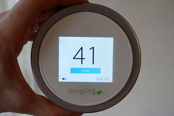
Laser egg showing air pollution levels using the US air quality index. [Photo provided to chinadaily.com.cn]
China will build a comprehensive network to detect pollution of the land, sea and air by 2020, employing satellites, drones and remote sensors to monitor the environment.
The national leadership approved the network plan in July, saying the government will lead the monitoring, share information among departments and regions, and be held accountable if violations are found, the Ministry of Environmental Protection said on Tuesday.
Satellites, a major tool for monitoring air pollution, will receive a boost this year. The ministry said it will accelerate research on two atmospheric environmental monitoring satellites and two satellites with higher resolution than those currently available.
The ministry will improve a remote sensor network, guided by the goals of the 13th Five-Year Plan (2016-20), which is scheduled to be released at the end of this year, according to the ministry's Environmental Supervision Department.
Remote monitoring has played a bigger role in locating pollution sources. Drones helped authorities locate polluted areas in the Tengger Desert in northern China and identify scattered summer straw burnings.
Hebei province, which has a serious air pollution problem, has cooperated with the ministry's Satellite Environment Center to conduct monitoring from satellites and monitoring stations since January last year.
"We used the data from the center's satellites to forecast the movement of smog during the Asia-Pacific Economic Cooperation meetings in November," Zhang Feng, an engineer in the Environmental Supervision Department of the provincial environmental watchdog, said on Tuesday.
Data collected from monitoring stations helped authorities provide accurate forecasts on hazy days during that period, he said.
Currently, the environmental satellites are used as support tools, as there are not enough of them, Zhang said. After the province builds a system to analyze and process data by the end of this year, the satellites will become more important.
The ministry will also strengthen the supervision of data collected through multiple channels, which is "important to keep the environmental management policies and measures effective and scientific", Chen Jining, the environmental minister, said in July.
 Beauty of Tsinghua University transforms into car model
 Mums stage breastfeeding flash mob
 Moscow “spider-man” climbs Chinese skyscraper
 No cleavage allowed at China’s largest gaming expo this year
 Photo story: A model’s breast implant surgery
 Student proposes during graduation ceremony
 Kiss contest held in Nanning, SW China
 Bikini beauties lifeguards in river rafting place
 An unbreakable army
 Sharing with strangers
 US cyber ‘retaliation’ shows hypocrisy
 Markets fall again despite govt support
 China’s police dogs train to sniff out crime
Day|Week
 久久精品视频免费试看